
চিত্র:The Portuguese Empire.png

এই প্রাকদর্শনের আকার: ৮০০ × ৪০৭ পিক্সেল। অন্যান্য আকারসমূহ: ৩২০ × ১৬৩ পিক্সেল | ৬৪০ × ৩২৫ পিক্সেল | ১,০২৪ × ৫২১ পিক্সেল | ১,২৮০ × ৬৫১ পিক্সেল | ২,৭৫৩ × ১,৪০০ পিক্সেল।
মূল ফাইল (২,৭৫৩ × ১,৪০০ পিক্সেল, ফাইলের আকার: ২৩২ কিলোবাইট, এমআইএমই ধরন: image/png)

|
This locator map image could be re-created using vector graphics as an SVG file. This has several advantages; see Commons:Media for cleanup for more information. If an SVG form of this image is available, please upload it and afterwards replace this template with
{{vector version available|new image name}}.
It is recommended to name the SVG file “The Portuguese Empire.svg”—then the template Vector version available (or Vva) does not need the new image name parameter. |
সারাংশ
| বিবরণ |
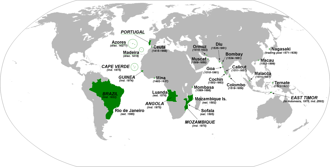
English: The principal forts, trading posts and colonies of the Portuguese Empire (1415-1999).
Abbreviations: disc: date of discovery est: date of establishment ind: date of independence Present-day Portuguese territory is underlined in green. |
| তারিখ | |
| উৎস | নিজের কাজ |
| লেখক | The Red Hat of Pat Ferrick |
লাইসেন্স প্রদান
| আমি, এই কাজের স্বত্বাধিকারী, এতদ্দ্বারা আমি এই কাজকে পাবলিক ডোমেইন লাইসেন্সের আওতায় প্রকাশ করলাম। এটি বিশ্বব্যাপী প্রযোজ্য হবে। কিছু দেশে এটি আইনত সিদ্ধ নাও হতে পারে, যদি তাই হয়: আমি যে-কাউকে এই কাজটি যেকোনো উদ্দেশ্যে, বিনাশর্তে ব্যবহারের অনুমতি প্রদান করছি, যদি না সেই শর্তগুলো আইনত প্রয়োজনীয় হয়। |
ফাইলের ইতিহাস
যেকোনো তারিখ/সময়ে ক্লিক করে দেখুন ফাইলটি তখন কী অবস্থায় ছিল।
| তারিখ/সময় | সংক্ষেপচিত্র | মাত্রা | ব্যবহারকারী | মন্তব্য | |
|---|---|---|---|---|---|
| বর্তমান | ০১:৪৬, ৩ ফেব্রুয়ারি ২০১৮ | | ২,৭৫৩ × ১,৪০০ (২৩২ কিলোবাইট) | 42800141 | Removed the state of Acre from the rest of Brazil and the border between Brazil and Uruguay |
| ০২:০২, ৮ জানুয়ারি ২০০৯ |  | ২,৭৫৩ × ১,৪০০ (২১৪ কিলোবাইট) | The Red Hat of Pat Ferrick | lose a few arrows | |
| ০২:১৬, ৫ জানুয়ারি ২০০৯ |  | ২,৭৫৩ × ১,৪০০ (২২৩ কিলোবাইট) | The Red Hat of Pat Ferrick | forgot E. Timor | |
| ০১:০৯, ৫ জানুয়ারি ২০০৯ |  | ২,৭৫৩ × ১,৪০০ (২১৪ কিলোবাইট) | The Red Hat of Pat Ferrick | Underlines for present day Portuguese territory | |
| ০০:৪৯, ৫ জানুয়ারি ২০০৯ |  | ২,৭৫৩ × ১,৪০০ (২১৪ কিলোবাইট) | The Red Hat of Pat Ferrick | Arrow for Ceuta | |
| ০০:৪৬, ৫ জানুয়ারি ২০০৯ |  | ২,৭৫৩ × ১,৪০০ (২১৩ কিলোবাইট) | The Red Hat of Pat Ferrick | {{Information |Description={{en|1=The principle forts, trading posts and colonies of the Portuguese Empire (1415-1999). Abbreviations: est: date of establishment ind: date of independence }} |Source=Own work |Author=[[User:The Red Hat of Pat Ferrick|The |
ফাইলের ব্যবহার
নিম্নলিখিত 2টি পাতা এই ফাইল ব্যবহার করে:
ফাইলের বৈশ্বিক ব্যবহার
নিচের অন্যান্য উইকিগুলো এই ফাইলটি ব্যবহার করে:
- ar.wikipedia.org-এ ব্যবহার
- ca.wikipedia.org-এ ব্যবহার
- de.wikipedia.org-এ ব্যবহার
- el.wikipedia.org-এ ব্যবহার
- en.wikipedia.org-এ ব্যবহার
- en.wikibooks.org-এ ব্যবহার
- et.wikipedia.org-এ ব্যবহার
- fa.wikipedia.org-এ ব্যবহার
- fr.wikipedia.org-এ ব্যবহার
- gl.wikipedia.org-এ ব্যবহার
- id.wikipedia.org-এ ব্যবহার
- incubator.wikimedia.org-এ ব্যবহার
- it.wikipedia.org-এ ব্যবহার
- kaa.wikipedia.org-এ ব্যবহার
- oc.wikipedia.org-এ ব্যবহার
- pl.wikipedia.org-এ ব্যবহার
- pt.wikibooks.org-এ ব্যবহার
- qu.wikipedia.org-এ ব্যবহার
- sc.wikipedia.org-এ ব্যবহার
- uk.wikipedia.org-এ ব্যবহার
- uz.wikipedia.org-এ ব্যবহার
- zh.wikibooks.org-এ ব্যবহার